












If you land in the capital and plan to reach the southeast coast, the first question is simple. How far is Santo Domingo to La Romana? The road distance is about 64 miles, or roughly 103 kilometers. Most travelers cover it in 90 minutes to two hours. Here is exactly how to make the trip without wasting time or money.
How Far Is Santo Domingo to La Romana by Road
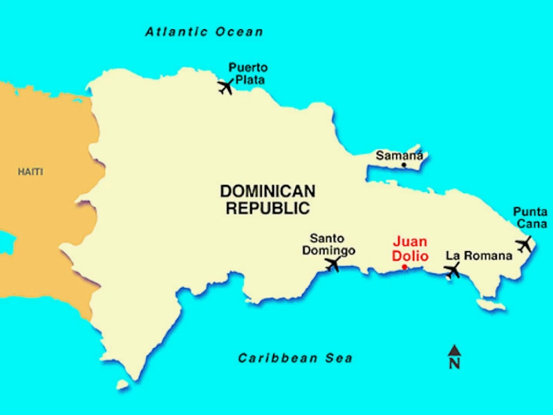
Santo Domingo and La Romana both sit on the southern coast of the Dominican Republic. The driving distance between the two cities is around 64 miles (103 km). The straight-line distance is shorter, close to 50 miles, but no direct path exists over water and open country.
La Romana is the capital of La Romana Province. It lies east of Santo Domingo, past the city of San Pedro de Macorís. The gap is small by Caribbean standards, which is why day trips between the two are common.
How Long Does the Drive Take?
Plan for 90 minutes to two hours in normal traffic. The main route is the Autovía del Este, the toll highway that runs along the southeastern coast. It is modern, well paved, and the fastest option.
Leaving Santo Domingo during rush hour adds time. Traffic inside the capital is the slowest part of the whole trip. Once you clear the city limits, the highway moves quickly.
Ways to Travel from Santo Domingo to La Romana
You have three realistic options. Each fits a different budget and comfort level.
- Private transfer or taxi: The fastest and most comfortable choice. A driver takes you door to door in under two hours. It costs more, but you skip transfers and waiting.
- Public bus or guagua: The budget pick. Regional buses and shared vans connect Santo Domingo with the eastern provinces. Fares are low, though you may change vehicles and stops are frequent.
- Rental car: The flexible choice. You control the schedule and can stop along the way. Remember to budget for highway tolls on the Autovía del Este.
My advice is clear. If you are a group or carry luggage, book a private transfer. If you travel solo and watch your budget, the bus works fine.
What Is There to See in La Romana?
La Romana rewards the short drive. The town is best known for Casa de Campo, one of the largest resort communities in the Caribbean. Nearby sits Altos de Chavón, a replica 16th century Mediterranean village built above the Chavón River.
The coast also opens the door to Isla Catalina and Isla Saona, two of the country’s most photographed islands. La Romana International Airport (LRM) serves the area directly for visitors who prefer to skip the capital entirely.
Smart Tips Before You Go
A few habits make the trip smoother. First, carry small bills in Dominican pesos for tolls and local buses. Second, travel in daylight if you drive yourself, since rural road signs can be sparse after dark.
Staying connected matters too. Maps, transfer bookings, and ride apps all need a stable signal the moment you land. A Santo Domingo eSIM with Holafly lets you go online before you leave the airport, with no SIM swap and no roaming shock. For the road itself, a good set of wireless earbuds under 200 dollars turns the two-hour drive into easy listening.
Frequently Asked Questions
Is there a direct bus from Santo Domingo to La Romana?
Yes. Regional buses and shared vans run east from Santo Domingo toward the La Romana area throughout the day. Service is frequent, but schedules can shift, so confirm the first and last departures.
Can I drive myself between the two cities?
Absolutely. The Autovía del Este is a modern toll highway that connects both cities. A rental car gives you freedom to stop in San Pedro de Macorís or at the coast along the way.
How much does a private transfer cost?
Prices vary by season and vehicle size. A private transfer is the premium option, so expect to pay more than the bus. Groups often find the per person cost reasonable when split.
Should I fly instead of driving?
For such a short distance, flying rarely makes sense. La Romana International Airport mainly serves travelers arriving from abroad, not short hops from the capital. The highway is faster once you factor in airport waiting.
Is the drive safe?
The main highway is in good condition and widely used. Drive in daylight when possible, keep to the toll road, and use a reliable map app to stay on route.